Summary
MotionInfo, in coordination with the UNH Center for Coastal & Ocean Mapping (CCOM) and UNH marine operations, conducted a live test of the StationKeeper AIS messaging system by transmitting test safety messages from the company's AIS transmit equipment at the Portsmouth Lighthouse to UNH research vessels and documenting how the messages appeared on the vessels' navigation displays.
The purpose was to confirm real-world reception and to document, with photos and video, how an AIS application-specific / safety message renders on the chart plotters and AIS units actually installed on working research vessels. The work supports MotionInfo's NOAA project to message mariners in real time to reduce North Atlantic right whale vessel strikes.
Test Result
On the morning of July 10, 2026, MotionInfo transmitted test messages from the Portsmouth Lighthouse. Juliet Kinney (UNH CCOM) was dockside and Franny Lux (UNH marine operations) was aboard with the vessel navigation displays powered on. The transmit pattern was one message per minute, repeated four times. UNH confirmed reception and captured photo/video of the messages as they appeared on the vessels' displays.
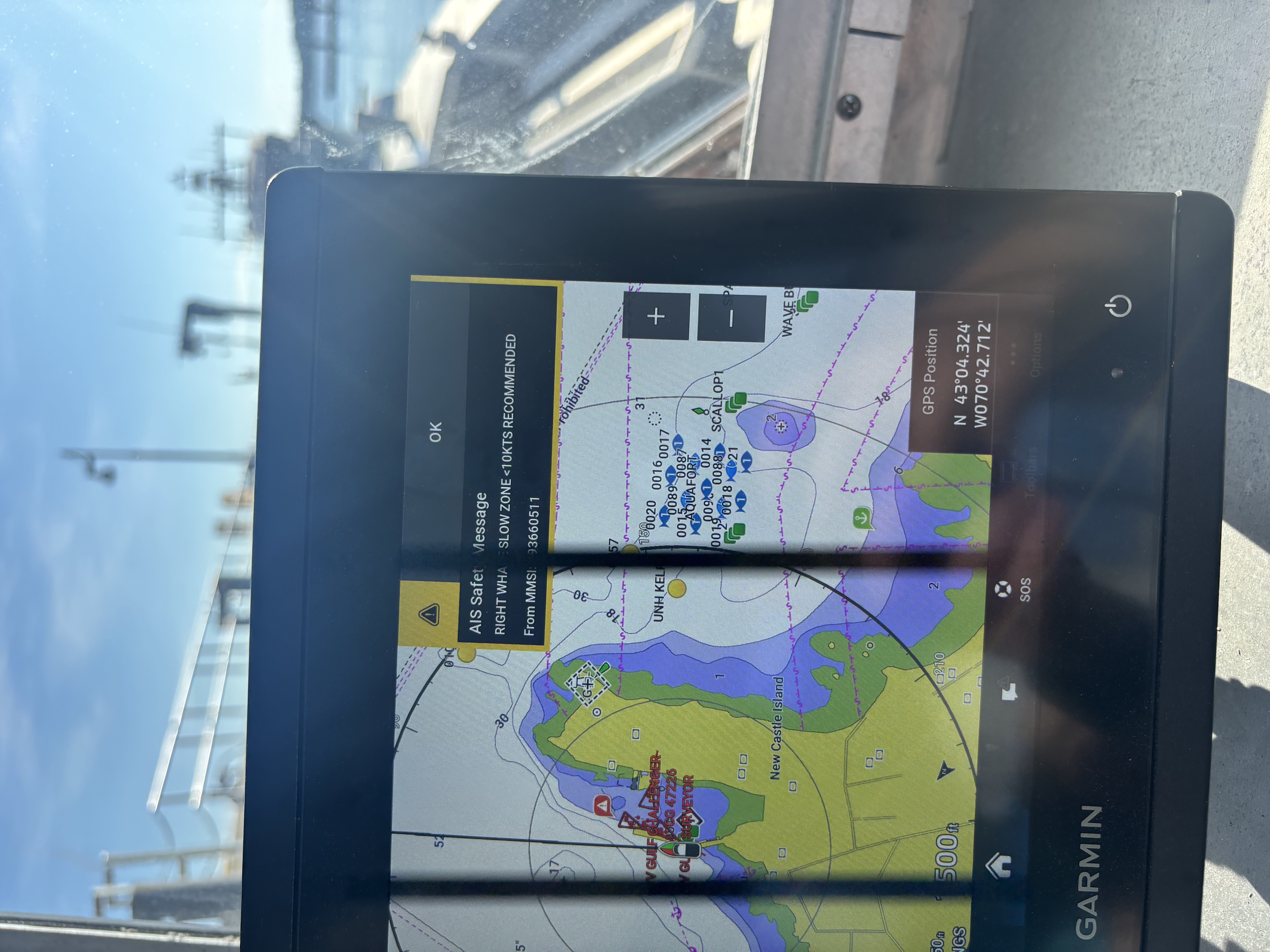
The captured photo of the Tego's Garmin plotter confirms the transmitted content rendered on-vessel as a native AIS Safety Message reading "RIGHT WHALE … SLOW ZONE <10KTS RECOMMENDED" (From MMSI …93660511), with the vessel at N 43°04.324′ W070°42.712′ in Portsmouth Harbor and the UNH fleet visible as AIS targets on the chart. See the Media section below.
Per-vessel results
| Vessel | Nav / AIS equipment | Message received | Media captured |
|---|---|---|---|
| R/V Gulf Challenger | RosePoint Coastal Explorer navigation software | Confirmed | Video |
| Tego | Garmin plotter · Si-Tex MDA-1 Metadata Class B AIS transceiver · RosePoint Coastal Explorer | Confirmed | Photo + video |
| R/V Gulf Surveyor | (To be coordinated via vessel captain) | Not documented this round | — |
Media — Displays Showing the Received Message
Captured on-vessel by UNH (Franny Lux), July 10, 2026, on the vessels' own navigation equipment.
🔊 Turn your audio up — the Tego video below has sound; you can hear the vessel's audible AIS alarm as the safety message arrives.
How It Happened — Timeline
- May 8, 2026MotionInfo → Franny Lux & Nate Rennels (UNH)Initial request: MotionInfo maintains AIS transmit equipment at the Portsmouth Lighthouse and asks to send test messages to the R/V Gulf Challenger, R/V Gulf Surveyor, and Tego, requesting chart-plotter screenshots. Shared the NOAA feature story and StationKeeper program links.
- May 8, 2026Franny Lux (UNH) → MotionInfoUNH agrees to provide photos of the Challenger and Tego; loops in the Surveyor's captain for that vessel.
- May 12, 2026MotionInfo → UNHProposes a formal documented test — messages photographed/filmed on the plotters both at the dock and at maximum offshore range — and requests AIS/chart-plotter make and model.
- Jul 6–9, 2026Juliet Kinney (CCOM) ↔ Franny Lux ↔ MotionInfoJuliet re-engages to observe a live push to the Tego; scheduling converges on an early-morning dock test. Franny confirms the Tego will be available; MotionInfo confirms it can transmit from the lighthouse.
- Jul 10, 2026 — ~08:00On-vessel testJuliet dockside; Franny aboard with displays on. MotionInfo transmits from the lighthouse — one message per minute, four times. Franny confirms: "It went through, we got video and pictures." Media captured for the Gulf Challenger (RosePoint) and Tego (Garmin).
- Jul 13–14, 2026Follow-upJuliet requests vessel specs / suggests an AIS-and-nav-software inventory of the UNH fleet. Captain Dan reports the Tego runs a Si-Tex MDA-1 Metadata Class B AIS transceiver with RosePoint Coastal Explorer.
Vessels & Equipment
| Vessel | Operator | AIS transceiver | Nav software / plotter |
|---|---|---|---|
| Tego | UNH | Si-Tex MDA-1 Metadata Class B AIS | Garmin plotter; RosePoint Coastal Explorer |
| R/V Gulf Challenger | UNH | — | RosePoint Coastal Explorer |
| R/V Gulf Surveyor | UNH | — (via captain) | — |
Transmit site: MotionInfo AIS equipment at the Portsmouth / Fort Point Lighthouse, Portsmouth Harbor, NH.
Participants
| Juliet Kinney, Ph.D. | Multibeam Mapping & Data Research Analyst, UNH CCOM/JHC — coordinated the observation, dockside on test day |
| Franny Lux | UNH marine operations — aboard the vessel, captured the photo/video |
| Nate Rennels | UNH — initial coordination |
| Capt. Dan | UNH — provided Tego AIS/nav equipment details |
| Moses Calouro | Maritime Information Systems, Inc. / MotionInfo — transmitted the test messages |
References
NOAA Fisheries — Messaging Mariners in Real Time to Reduce North Atlantic Right Whale Vessel Strikes →
MotionInfo — StationKeeper program →
A.W.A.R.E. Dashboard (program-wide message & acknowledgement data, PDF) →